


NVS310 High -precision combined navigation and positioning system of car
● The design is used at the vehicle level to increase the reliability of equipment
● Due to the good design of the interaction of a person and machine, the indication of the state is intuitive, and the state of the power source, the status of access to satellite information, the status of access to information about the vehicle, the condition of the equipment and other information are shown to the user using light indicators.
● Integrates the wheel tachometer, transmission of car and other information
● supports data storage applications and post -cutting
● RTK in real time, positioning at the centimeter level
● high resistance to vibration and shock, work at full temperature
Product Introduction:
NVS310 is a high -precision combined positioning and real -time navigation, designed and manufactured on the basis of MMMS inertial navigation technology, integrating differential GPS, supporting RTK and information about the vehicle rotation, transfer, etc.) and corresponding to the standards of the vehicle.
Features:
It can provide the vehicle with information about the position, speed, location and other information around the clock and in various scenarios (viaducts, underground garages, tunnels, city streets, ports, etc.).
Application:
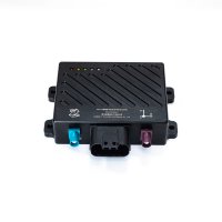
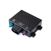
The product uses a good “man-machine” design and can display the condition of the power source, the status of access to satellite information, the status of access to information about the vehicle, the state of equipment and other information for the user using light indicators. The hardware interface (connector) has a design protected from errors to facilitate user production, scientific research and debugging.
Technical Specification:
Показатель | ||
Система | ||
Крен/тангаж(1) | 0.1° | |
Точность выхода GNSS из-под контроля (бортовой CEP) | Смещение положения(1km/2min) | 0.20% |
Дрейф по курсу(1min) | 0.15° | |
Гироскоп | ||
Диапазон | 250° /s | |
Стабильность нулевого смещения (10s Плавность) | ≤5° /h | |
Нестабильность нулевого смещения (1 | 2° /h | |
Нулевое смещение в полной температуре | ≤0.08° /h | |
Акселерометр | ||
Диапазон | 20g | |
Стабильность нулевого смещения (10s Плавность) | ≤0.1mg | |
Нулевое смещение в полной температуре | ≤2mg | |
Печатная плата спутниковой навигации | ||
Положение(RMS) | 1.5m,2cm+1ppm(RTK) | |
Скорость(RMS) | 0.03 m/s | |
Курс(RMS) | 0.15°(Базовая линия 1m) | |
Диапазон частот | BDS B1/B2 + GPS L1/L2 + GLONASS L1/L2 | |
Электрический интерфейс | ||
Входное напряжение | 12V(DC 9~16V) | |
Рабочий ток | ≤0.25A | |
Тип интерфейса | RS422 *1(Интерфейс данных ),RS232 *1(Дифференциальный интерфейс),CAN *2 | |
Тип разъемного соединителя | MX23A18NF1(шин),FAKRA_C(Главная антенна)、FAKRA_D(От антенны.),DB9(Каждое отверстие данных),DJ7021-1.5-21(питан),DJ7021-1.5-22(питан) | |
Главный механизм | ||
Вес | <400g | |
Размер | 116*99.90*30mm | |
Материал корпуса | алюминиевый сплав | |
Рабочая температура | -40℃ ~ 85℃ | |
Кабель для передачи данных | ||
Тип интерфейса | MX23A18SF1 | |
Длина | 1.5m | |
Антенна (опционально) | ||
Размер | 152*152*62.2mm | |
Вес(Отдельный ) | 433.5g | |
Антенный фидер(опционально) | ||
Тип интерфейса | FAKRA_Z (Подключить к позиционирующей антенне_M)поверн TNC、 FAKRA_D (Подключить к позиционирующей антенне_S)поверн TNC | |
Размер | 5m(по умолчанию) | |
Вес(Отдельный) | 30g(по умолчанию) | |